پرونده:Yorkshire and the Humber counties 2009 map.svg

حجم پیشنمایش PNG این SVG file:۷۰۵ × ۶۰۰ پیکسل دیگه کیفیتون: ۲۸۲ × ۲۴۰ پیکسل | ۵۶۴ × ۴۸۰ پیکسل | ۹۰۳ × ۷۶۸ پیکسل | ۱٬۲۰۴ × ۱٬۰۲۴ پیکسل | ۲٬۴۰۸ × ۲٬۰۴۸ پیکسل | ۱٬۴۲۵ × ۱٬۲۱۲ پیکسل.
اصلی پرونده (اسویجی ِپرونده، ابعاد ۱٬۴۲۵ × ۱٬۲۱۲ پیکسل جه، پرونده قایده: ۱٫۲۵ مگابایت)
|
|
این پرونده ویکیتلمبار دله دَره. ونه دلهی بنویشتهئون (مازرونی) ره اینجه سِراق دنه. |
گزارش
| توضیح |
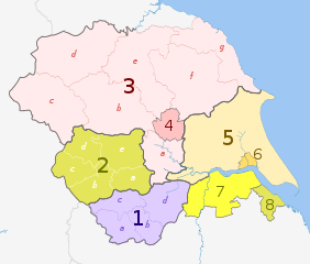
English: Map of the Yorkshire and the Humber region of England, showing its counties and administrative districts until 31 March 2023. The county colours are the same as those in File:English metropolitan and non-metropolitan counties 2009.svg.
For districts after 1 April 2023, see File:Yorkshire and the Humber counties 2023 map.svg. Equirectangular map projection on WGS 84 datum, with N/S stretched 170% Geographic limits:
|
| تاریخ | (UTC) |
| منبع |
این پرونده مشتق شدهاست از: |
| سازنده |
|
| دیگر نسخهها |
|

| Map | Ceremonial county | County / unitary | Districts |
|---|---|---|---|
 |
1. South Yorkshire * | a) Sheffield, b) Rotherham, c) Barnsley, d) Doncaster | |
| 2. West Yorkshire * | a) Wakefield, b) Kirklees, c) Calderdale, d) Bradford, e) Leeds | ||
| North Yorkshire (part only) |
3. North Yorkshire † | a) Selby, b) Harrogate, c) Craven, d) Richmondshire, e) Hambleton, f) Ryedale, g) Scarborough | |
| 4. York U.A. | |||
| East Riding of Yorkshire | 5. East Riding of Yorkshire U.A. | ||
| 6. Kingston upon Hull U.A. | |||
| Lincolnshire (part only) |
7. North Lincolnshire U.A. | ||
| 8. North East Lincolnshire U.A. | |||
Key: †shire county | *metropolitan county
اجازهنومه
این پرونده کریتیو کامانز اجازهنومه جه Attribution-Share Alike 3.0 سازگار نییه و منتشر بیه.
مجوز: Dr Greg and Nilfanion. Contains Ordnance Survey data © Crown copyright and database right 2011
- شما اجازه دارنی:
- همباز بیّن وسّه – پروندهی ِکپی، توزیع و انتقال وسّه
- پشو بزوئن – پروندهی انطباق وسّه
- این شرایط جه:
- تخصیص – شما ونه اتجور بنویسین که اثر ِصاحاب ره نسبت هِدا بَوو، نا اینکه اتی بنویسین که مخاطبون فکر هاکنِن اون آدِم شمه بنویشته ره تأیید کانده.
- همباز هاکردن – اگه عکس سَر فقط اتکه تغییر هِدانی، بتونّی همون مجوز جه استفاده هاکنین.
سیاهه بارگذاری اصلی
This image is a derivative work of the following images:
- File:Yorkshire_and_the_Humber_districts_2011_map.svg licensed with Cc-by-sa-3.0, GFDL
- 2011-05-01T19:07:00Z Nilfanion 1425x1212 (1275424 Bytes) == Summary == {{Information |Description=Map of the [[w:Yorkshire and the Humber|Yorkshire and the Humber]] region showing the administrative districts. Equirectangular map projection on WGS 84 datum, with N/S stretched 170%
- File:English_ceremonial_counties_2010.svg licensed with Cc-by-sa-3.0, GFDL
- 2010-11-23T16:39:55Z Nilfanion 1108x1345 (308868 Bytes) thicker lines
- 2010-11-23T16:20:19Z Nilfanion 1108x1345 (301520 Bytes) tweaks
- 2010-10-26T20:34:20Z Nilfanion 817x990 (1391832 Bytes) {{Information |Description=Map showing the [[w:ceremonial counties of England]] including the City of London, in 2010. Equirectangular map projection on WGS 84 datum, with N/S stretched 170% Geographic limits: *West: 6.75W
Uploaded with derivativeFX
فایل تاریخچه
تاریخ/زمونها سَر کلیک هاکنین تا اون گدِر ِنسخه ره هارشین.
| تاریخ/زمون | انگوسگتی | ابعاد | کارور | توضیح | |
|---|---|---|---|---|---|
| إسا | ۲ مه ۲۰۱۲، ساعت ۲۱:۳۸ | | ۱٬۴۲۵ در ۱٬۲۱۲ (۱٫۲۵ مگابایت) | Dr Greg | == {{int:filedesc}} == {{Information |Description={{en|Map of the Yorkshire and the Humber region of England, showing its counties and administrative districts. The county colours are the same as those in [[:File:English ... |
پروندهی استفاده
این صفحه لینک هِدانه این فایل ره:
پروندهیِ گِردِ استفادهئون
این ویکیون هم این پرونده جه استفاده کانّه:
- کاربرد ar.wikipedia.org دله
- کاربرد bn.wikipedia.org دله
- کاربرد en.wikipedia.org دله
- کاربرد fa.wikipedia.org دله
- کاربرد frr.wikipedia.org دله
- کاربرد fr.wikipedia.org دله
- کاربرد hr.wikipedia.org دله
- کاربرد hu.wikipedia.org دله
- کاربرد mr.wikipedia.org دله
- کاربرد pl.wikipedia.org دله
- کاربرد pnb.wikipedia.org دله
- کاربرد pt.wikipedia.org دله
- کاربرد th.wikipedia.org دله
- کاربرد ur.wikipedia.org دله
- کاربرد vi.wikipedia.org دله
- کاربرد vls.wikipedia.org دله
- کاربرد zh-yue.wikipedia.org دله