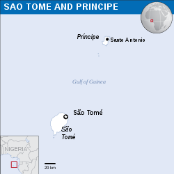
پرونده:São Tomé and Príncipe - Location Map (2013) - STP - UNOCHA.svg

حجم پیشنمایش PNG این SVG file:۲۵۰ × ۲۵۰ پیکسل دیگه کیفیتون: ۲۴۰ × ۲۴۰ پیکسل | ۴۸۰ × ۴۸۰ پیکسل | ۷۶۸ × ۷۶۸ پیکسل | ۱٬۰۲۴ × ۱٬۰۲۴ پیکسل | ۲٬۰۴۸ × ۲٬۰۴۸ پیکسل.
اصلی پرونده (اسویجی ِپرونده، ابعاد ۲۵۰ × ۲۵۰ پیکسل جه، پرونده قایده: ۳۴۸ کیلوبایت)
فایل تاریخچه
تاریخ/زمونها سَر کلیک هاکنین تا اون گدِر ِنسخه ره هارشین.
| تاریخ/زمون | انگوسگتی | ابعاد | کارور | توضیح | |
|---|---|---|---|---|---|
| إسا | ۱۰ سپتامبر ۲۰۱۶، ساعت ۰۶:۰۹ |  | ۲۵۰ در ۲۵۰ (۳۴۸ کیلوبایت) | Wereldburger758 | Resized page to drawing. Removal watermark. Validation of image. |
| ۸ مه ۲۰۱۴، ساعت ۰۱:۱۴ |  | ۲۵۴ در ۲۵۴ (۳۷۲ کیلوبایت) | UN OCHA maps bot | == {{int:filedesc}} == {{Information |description={{en|1=Locator map of São Tomé and Príncipe.}} |date=2013 |source={{en|1=[http://reliefweb.int/map/sao-tome-and-principe/sao-tome-and-principe-location-map-2013 Sao... |
پروندهی استفاده
این صفحه لینک هِدانه این فایل ره:
پروندهیِ گِردِ استفادهئون
این ویکیون هم این پرونده جه استفاده کانّه:
- کاربرد ar.wikipedia.org دله
- کاربرد arz.wikipedia.org دله
- کاربرد ast.wikipedia.org دله
- کاربرد ca.wikipedia.org دله
- کاربرد ceb.wikipedia.org دله
- کاربرد ee.wikipedia.org دله
- کاربرد el.wikipedia.org دله
- کاربرد en.wikipedia.org دله
- کاربرد eo.wikipedia.org دله
- کاربرد es.wikipedia.org دله
- کاربرد eu.wikipedia.org دله
- کاربرد ga.wikipedia.org دله
- کاربرد gl.wikipedia.org دله
- کاربرد ha.wikipedia.org دله
- کاربرد ht.wikipedia.org دله
- کاربرد hu.wikipedia.org دله
- کاربرد ia.wikipedia.org دله
- کاربرد id.wikipedia.org دله
- کاربرد kab.wikipedia.org دله
- کاربرد la.wikipedia.org دله
- کاربرد mdf.wikipedia.org دله
- کاربرد pl.wikipedia.org دله
- کاربرد pt.wikipedia.org دله
- کاربرد sd.wikipedia.org دله
- کاربرد szl.wikipedia.org دله
- کاربرد te.wikipedia.org دله
- کاربرد tt.wikipedia.org دله
- کاربرد uk.wikipedia.org دله
- کاربرد vi.wikipedia.org دله
- کاربرد www.wikidata.org دله
- کاربرد zh-yue.wikipedia.org دله
