پرونده:Harlan Kentucky Aerial view.jpg

این پیش-پیش سِراق هدائن ِقایده: ۸۰۰ × ۵۳۳ پیکسل. دیگه کیفیتون: ۳۲۰ × ۲۱۳ پیکسل | ۶۴۰ × ۴۲۷ پیکسل | ۱٬۰۲۴ × ۶۸۳ پیکسل | ۱٬۵۰۰ × ۱٬۰۰۰ پیکسل.
اصلی پرونده (۱٬۵۰۰ × ۱٬۰۰۰ پـیـکـسهل, فـایـل گـأتـی: ۷۳۲ کیلوبایت, MIME مـونـد: image/jpeg)
|
|
این پرونده ویکیتلمبار دله دَره. ونه دلهی بنویشتهئون (مازرونی) ره اینجه سِراق دنه. |
| توضیح |
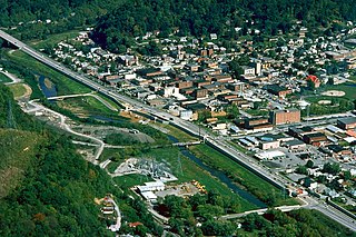
English: Aerial view of Harlan, Kentucky, USA. View is to the northeast. The main highway, U.S. Route 421, runs diagonally across the picture. The U.S. Army Corps of Engineers has constructed levees and a long floodwall along the Martins Fork River to prevent recurrence of the disastrous floods of 1977. |
|||
| تاریخ | ||||
| منبع |
U.S. Army Corps of Engineers Digital Visual Library Image page Image description page Digital Visual Library home page |
|||
| سازنده | U.S. Army Corps of Engineers, photographer not specified or unknown | |||
| اجازهنومه (این فایل جه أی اٮستفاده هاکردن) |
|
|||
| مکان | Harlan, Kentucky, USA |
| مختصات دوربین | | محل قرارگیری این نگاره و سایر نگارهها در: نقشهٔ شهری باز |
|---|
فایل تاریخچه
تاریخ/زمونها سَر کلیک هاکنین تا اون گدِر ِنسخه ره هارشین.
| تاریخ/زمون | انگوسگتی | ابعاد | کارور | توضیح | |
|---|---|---|---|---|---|
| إسا | ۲۵ مارس ۲۰۰۷، ساعت ۰۲:۲۲ | | ۱٬۵۰۰ در ۱٬۰۰۰ (۷۳۲ کیلوبایت) | DanMS | {{Information | Description = {{en|Aerial view of Harlan, Kentucky, USA. View is to the northeast. The main highway, U.S. Route 421, runs diagonally across the picture. The U.S. Army Corps of Engineers has constructed levees and a long floodwall along |
پروندهی استفاده
این صفحه لینک هِدانه این فایل ره:
پروندهیِ گِردِ استفادهئون
این ویکیون هم این پرونده جه استفاده کانّه:
- کاربرد ar.wikipedia.org دله
- کاربرد arz.wikipedia.org دله
- کاربرد azb.wikipedia.org دله
- کاربرد ca.wikipedia.org دله
- کاربرد ceb.wikipedia.org دله
- کاربرد ce.wikipedia.org دله
- کاربرد en.wikipedia.org دله
- کاربرد es.wikipedia.org دله
- کاربرد eu.wikipedia.org دله
- کاربرد fa.wikipedia.org دله
- کاربرد ht.wikipedia.org دله
- کاربرد hu.wikipedia.org دله
- کاربرد id.wikipedia.org دله
- کاربرد io.wikipedia.org دله
- کاربرد it.wikipedia.org دله
- کاربرد lld.wikipedia.org دله
- کاربرد pl.wikipedia.org دله
- کاربرد pt.wikipedia.org دله
- کاربرد ru.wikipedia.org دله
- کاربرد sh.wikipedia.org دله
- کاربرد simple.wikipedia.org دله
- کاربرد sr.wikipedia.org دله
- کاربرد sv.wikipedia.org دله
- کاربرد tl.wikipedia.org دله
- کاربرد tr.wikipedia.org دله
- کاربرد tt.wikipedia.org دله
- کاربرد uz.wikipedia.org دله
- کاربرد www.wikidata.org دله
- کاربرد zh-min-nan.wikipedia.org دله