پرونده:Croatian Prevlaka in occupation by Montenegro and Serbia.jpg
ویشته رٮزولیشٮن ندارنه.
Croatian_Prevlaka_in_occupation_by_Montenegro_and_Serbia.jpg (۷۶۰ × ۵۶۰ پـیـکـسهل, فـایـل گـأتـی: ۱۱۸ کیلوبایت, MIME مـونـد: image/jpeg)
|
|
این پرونده ویکیتلمبار دله دَره. ونه دلهی بنویشتهئون (مازرونی) ره اینجه سِراق دنه. |
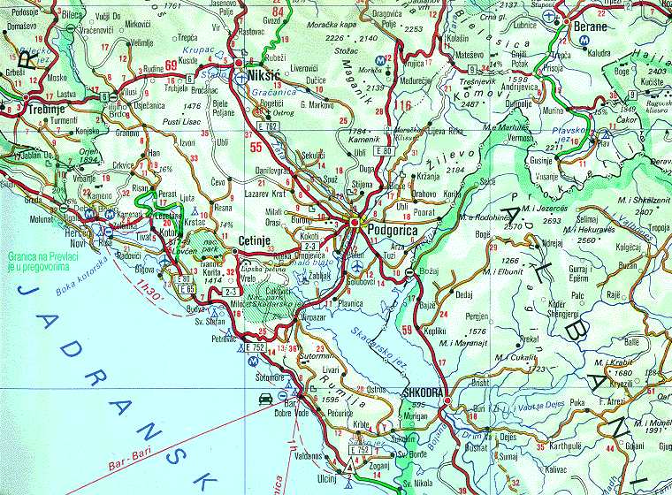
| توضیح | Map of Montenegrin Littoral Region and Boka kotorska in the time of occupation of Croatian Prevlaka Region which is the remaining part of Boka kotorska that belongs to Croatia. | |||
| تاریخ | 1991-2002 (occupation ended 1992-10-20 at 20:30) (UNMIK mission ended 2002-12-20). | |||
| منبع | Ministry of Foreign Affairs of the State Union Serbia and Montenegro (before that MFA of Federal Republic of Yugoslavia | |||
| سازنده | Serbian Official Cartography (Public Service at the time). | |||
| اجازهنومه (این فایل جه أی اٮستفاده هاکردن) |
|
|||
| دیگر نسخهها | Geographical version. |

فایل تاریخچه
تاریخ/زمونها سَر کلیک هاکنین تا اون گدِر ِنسخه ره هارشین.
| تاریخ/زمون | انگوسگتی | ابعاد | کارور | توضیح | |
|---|---|---|---|---|---|
| إسا | ۱۶ فوریه ۲۰۰۸، ساعت ۰۲:۰۵ | | ۷۶۰ در ۵۶۰ (۱۱۸ کیلوبایت) | Imbris~commonswiki | {{Information |Description=Map of Montenegrin ''Littoral Region'' and ''Boka kotorska'' in the time of occupation of Croatian hr:Prevlaka Region which is the remaining part of Boka kotorska that belongs to Croatia. |Source=[http://www.mfa.gov.yu/Fact |
پروندهی استفاده
این صفحه لینک هِدانه این فایل ره:
پروندهیِ گِردِ استفادهئون
این ویکیون هم این پرونده جه استفاده کانّه:
- کاربرد ca.wikipedia.org دله
- کاربرد ckb.wikipedia.org دله
- کاربرد de.wikipedia.org دله
- کاربرد en.wikipedia.org دله
- کاربرد fa.wikipedia.org دله
- کاربرد hr.wikipedia.org دله
- کاربرد id.wikipedia.org دله
- کاربرد nl.wikipedia.org دله
- کاربرد ru.wikipedia.org دله
- کاربرد sh.wikipedia.org دله
- کاربرد sq.wikipedia.org دله
- کاربرد www.wikidata.org دله
- کاربرد zh.wikipedia.org دله