پرونده:Congo regions named.png
ویشته رٮزولیشٮن ندارنه.
Congo_regions_named.png (۳۰۰ × ۳۳۷ پـیـکـسهل, فـایـل گـأتـی: ۱۴ کیلوبایت, MIME مـونـد: image/png)
|
|
این پرونده ویکیتلمبار دله دَره. ونه دلهی بنویشتهئون (مازرونی) ره اینجه سِراق دنه. |
| توضیح |
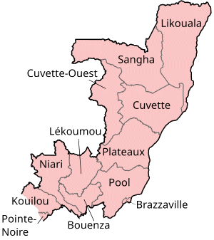
Map of the regions of the Republic of the Congo, named in French (local language), mostly compatible with English. The individual maps are: |
| تاریخ | |
| منبع | Self-made, traced from public domain UN or CIA maps. |
| سازنده | User:Golbez |
| اجازهنومه (این فایل جه دِباره استفاده هاکردن) |
Provide attribution, please. See below. |
من، صاحب حقوق قانونی این اثر، به این وسیله این اثر را تحث اجازهنامههای ذیل منتشر میکنم:
این پرونده با اجازهنامهٔ کریتیو کامانز Attribution-Share Alike 2.5 عمومی، 2.0 عمومی و 1.0 عمومی منتشر شده است.
- شما اجازه دارنی:
- اشتراک بییشتن وسّه – پروندهی ِکپی، توزیع و انتقال وسّه
- ریمیکس هاکردن – پروندهی انطباق وسّه
- این شرایط جه:
- تخصیص – شما ونه اتجور بنویسین که اثر ِصاحاب ره نسبت هِدا بَوو، نا اینکه اتتی بنویسین که مخاطبون فکر هاکنِن اون آدِم شمه بنویشته ره تأیید کانده.
- اتتی سهم – اگه عکس سَر فقط اتکه تغییر هِدانی، بتونّی همون مجوز جه استفاده هاکنین.

|
کپی، پخش یا تغییر ِاجازه این سند وسّه تحت شرایط گنویِ آزاد مستندات ِمجوز، نسخهٔ ۱٫۲ یا هر نسخهٔ بعدتری که آزاد نرمافزارون بنیاد باوّه، منتشر بیه؛ بدون بخشهای نامتغیر، متون روی جلد، و متون پشت جلد، هدائه وانه. اتا کپی مجوز جه گنویِ آزاد مستندات ِمجوز ِبخش دله ضمیمه بیه. |
| این پرونده کریتیو کامانز اجازهنومه جه Attribution-Share Alike 3.0 سازگار نییه و منتشر بگردسته. | ||
| ||
| این برچسب مجوز بهعنوان بخشی از روزآمدسازی مجوز GFDL، به این پرونده افزوده شد. |
بتونّی شه دِلِوِس ِمجوز ره انتخاب هاکنین.
فایل تاریخچه
تاریخ/زمونها سَر کلیک هاکنین تا اون گدِر ِنسخه ره هارشین.
| تاریخ/زمون | انگوسگتی | ابعاد | کارور | توضیح | |
|---|---|---|---|---|---|
| إسا | ۱ اکتبر ۲۰۲۳، ساعت ۱۷:۲۹ | | ۳۰۰ در ۳۳۷ (۱۴ کیلوبایت) | Yunan973 | fix all boundaries according to last offical maps (2023) |
| ۲۸ دسامبر ۲۰۰۴، ساعت ۱۶:۵۳ |  | ۳۰۰ در ۳۷۰ (۱۳ کیلوبایت) | Golbez | Map of the regions of the Republic of the Congo. Made by User:Golbez. {{cc-by-sa-2.0}} |
پروندهی استفاده
این صفحه لینک هِدانه این فایل ره:
پروندهیِ گِردِ استفادهئون
این ویکیون هم این پرونده جه استفاده کانّه:
- کاربرد ast.wikipedia.org دله
- کاربرد avk.wikipedia.org دله
- کاربرد be-tarask.wikipedia.org دله
- کاربرد bg.wikipedia.org دله
- کاربرد bn.wikipedia.org دله
- کاربرد br.wikipedia.org دله
- کاربرد ca.wikipedia.org دله
- کاربرد de.wikipedia.org دله
- کاربرد el.wikipedia.org دله
- کاربرد en.wikipedia.org دله
- Departments of the Republic of the Congo
- Pointe-Noire
- Districts of the Republic of the Congo
- User:Jonny-mt/Gallery of current first-level administrative country subdivisions maps
- Kimongo District
- Mayoko District
- Divénié District
- Louvakou District
- Template:Districts of the Republic of the Congo
- User talk:Markussep/Archive 4
- Kibangou District
- Moutamba District
- Boko-Songho District
- Loudima District
- Madingou District
- Mfouati District
- Mouyondzi District
- Kayes District
- Boundji District
- Loukela District
- Makoua District
- Mossaka District
- Okoyo District
- Oyo District
- Ewo District
- Kelle District
- Mbomo District
- Kakamoeka District
- Madingo-Kayes District
- Mvouti District
- Bambama District
- Komono District
- Sibiti District
- Zanaga District
- Dongou District
- Epena District
- Impfondo District
سراسری استفاده ره این پرونده جه سٮراق هاده.