پرونده:1850 Mitchell Map of Arabia, Persia, Afghanistan - Geographicus - Arabia-mitchell-1850.jpg
اصلی پرونده (۳٬۵۰۰ × ۲٬۸۶۵ پـیـکـسهل, فـایـل گـأتـی: ۲٫۷۷ مگابایت, MIME مـونـد: image/jpeg)
|
|
این پرونده ویکیتلمبار دله دَره. ونه دلهی بنویشتهئون (مازرونی) ره اینجه سِراق دنه. |
| عنوان |
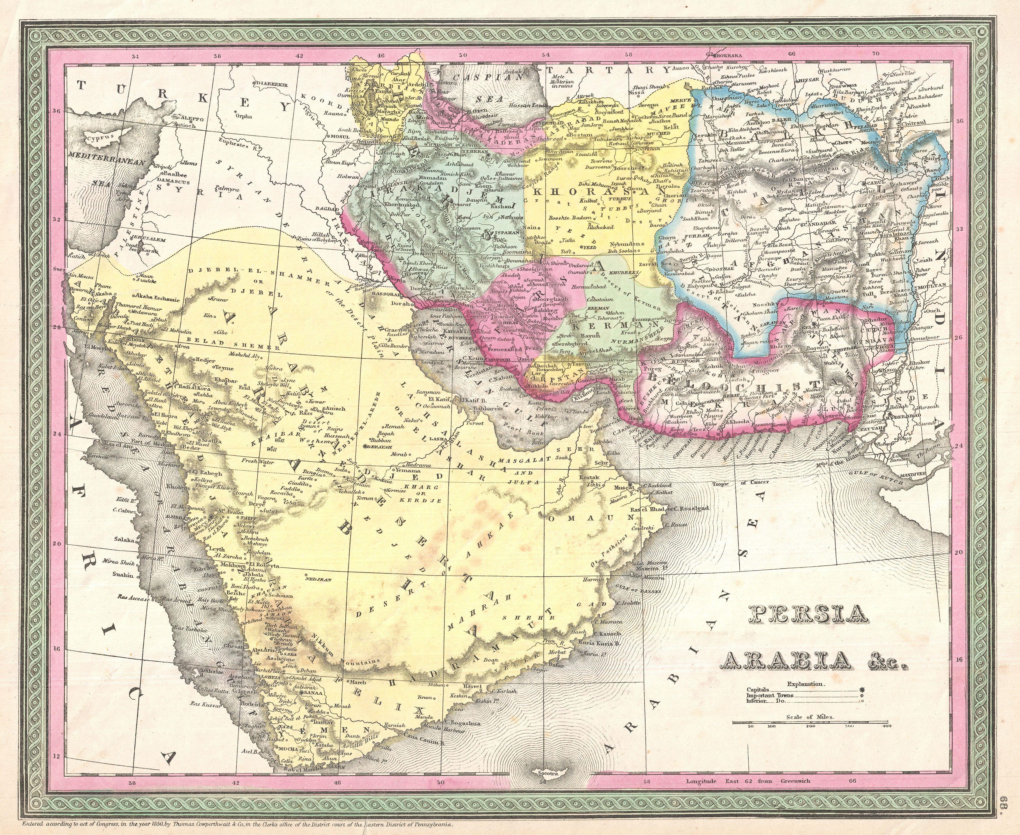
Persia, Arabia & C. |
|||||||||||||||||||
| Description |
English: A fine example of S. A. Mitchell Sr.'s important c. 1850 map of Arabia, Persia, and Afghanistan.
|
|||||||||||||||||||
| تاریخ | (dated) | |||||||||||||||||||
| منبع |
Mitchell Sr., S. A.,A New Universal Atlas Containing Maps of the various Empires, Kingdoms, States and Republics Of The World. (1850 issue)
|
|||||||||||||||||||
| پدیدآورنده |
|
|||||||||||||||||||
| اجازهنومه (این فایل جه دِباره استفاده هاکردن) |
|
|||||||||||||||||||
| Georeferencing | If inappropriate please set warp_status = skip to hide. | |||||||||||||||||||
| Archival data | ||||||||||||||||||||
| آیدی |
Geographicus link: Arabia-mitchell-1850 |
|||||||||||||||||||
| ابعاد | بلندی: ۱۲٫۵ اینچ (۳۱٫۷ سانتیمتر)؛ عرض: ۱۵٫۵ اینچ (۳۹٫۳ سانتیمتر) | |||||||||||||||||||
| دیگر نسخهها | ||||||||||||||||||||

|
فایل تاریخچه
تاریخ/زمونها سَر کلیک هاکنین تا اون گدِر ِنسخه ره هارشین.
| تاریخ/زمون | انگوسگتی | ابعاد | کارور | توضیح | |
|---|---|---|---|---|---|
| إسا | ۲۳ مارس ۲۰۱۱، ساعت ۲۱:۴۵ | | ۳٬۵۰۰ در ۲٬۸۶۵ (۲٫۷۷ مگابایت) | BotMultichillT | {{subst:User:Multichill/Geographicus |link=http://www.geographicus.com/P/AntiqueMap/Arabia-mitchell-1850 |product_name=1850 Mitchell Map of Arabia, Persia, Afghanistan |map_title=Persia, Arabia & C. |description=A fine example of S. A. Mitchell Sr.'s |
پروندهی استفاده
این صفحه لینک هِدانه این فایل ره:
پروندهیِ گِردِ استفادهئون
این ویکیون هم این پرونده جه استفاده کانّه:
- کاربرد fa.wikipedia.org دله
- ویکیپدیا:نگارههای برگزیده/نقشه
- درگاه:خراسان/نگاره برگزیده
- ویکیپدیا:گزیدن نگاره برگزیده/فوریه-۲۰۱۴
- ویکیپدیا:گزیدن نگاره برگزیده/1850 Mitchell Map of Arabia, Persia, Afghanistan - Geographicus - Arabia-mitchell-1850.jpg
- نقشه خاورمیانه ساموئل آگوستوس میشل
- ویکیپدیا:نگاره روز/دسامبر ۲۰۱۴
- الگو:نر/2014-12-20
- الگو:نر محافظت شده/2014-12-20
- بحث کاربر:Magic Wizard/بایگانی ۱
- درگاه:خراسان/نگاره برگزیده/۲۳